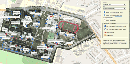
Orthomosaic: An aerial view of Carnegie Mellon University’s campus bounded by Forbes Avenue, Margaret Morrison Street, Frew Street, and Hamerschlag Drive. Each building entrance is labeled with an icon indicating the accessibility of the entrance. On the righthand side, users can select two buildings from the dropdown menus to see the shortest overall path and shortest wheelchair accessible path between those buildings. They can also select to view the underlying slope data that was used to determine which paths were wheelchair accessible.
Slope Data: The slope data shows that the algorithm correctly classified the sidewalks as paths and did not classify the grass or buildings as paths. Based on the 2010 ADA standards for ramp slopes, the paths are color coded as flat if the incline is less than 5%, accessible ramps if the incline is between 5% and 8.33%, and inaccessible if the incline is greater than 8.33%. Key features shown in this slope data are wheelchair accessible ramps leading into Doherty Hall and Posner Hall, inaccessible stairs throughout campus, and inaccessible ramps on the sidewalk that runs along the side of Doherty Hall and Wean Hall. In addition, the sidewalk leading from Forbes Avenue to Cyert Hall appears to be inaccessible for wheelchair users.
These routes were generated automatically using AI. In addition, this project currently only considers the 2010 ADA standards for ramp slopes (Section 405.2) and walking surface widths (Section 403.5.1). As a result the classification of routes as accessible or inaccessible is not guaranteed to be accurate. Learn more